As environmental restoration projects gain momentum, precision becomes paramount. In the case of the Eau Gallie A1 Muck Removal Project, meticulous surveying is essential to ensure the successful extraction of contaminated sediments while preserving the native ecosystem. Arc Surveying & Mapping, Inc., headquartered in Jacksonville, Florida, stands at the forefront of this endeavor, employing cutting-edge technology and expertise to deliver comprehensive surveying solutions.
Advancing Hydrographic and Geophysical Surveying
Under the direct supervision of Arc’s Florida Professional Surveyor, Certified Hydrographer, and Geologist, the surveying team orchestrates a meticulously planned approach. Leveraging state-of-the-art systems, Arc conducts hydrographic surveys to identify the interface between muck and native bottom with surgical precision. This critical data facilitates the targeted removal of contaminated sediments, minimizing disruption to the surrounding environment.
Arc’s Comprehensive Surveying Methodology
Arc’s scope of services encompasses a wide array of tasks aimed at delivering precise and actionable insights:
- Horizontal and Vertical Control: Arc ensures accurate positioning through the recovery or establishment of control points.
- Multibeam Swath Depth Survey: Employing advanced multibeam technology, Arc conducts comprehensive depth surveys of the dredging area.
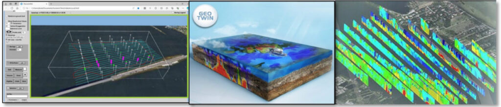
- Electrical Resistivity Geophysical Survey: Arc conducts geophysical surveys at 100 ft. line spacing, penetrating up to 30 ft. below the existing river bottom, verifying the muck interface with manual probes.
- Integration of Contract Plan Probes and Core Borings: Arc incorporates contract plan probes and core borings into the survey model for comparative analysis.
- Client Collaboration: Arc collaborates closely with clients to review survey findings and determine the need for additional core samples.
- Deliverables: Arc furnishes comprehensive reports, including bathymetric and geophysical survey data, presented in an ArcGeoTwin 3D Interactive Digital Geological Model.
Additional Resources:
National Oceanic and Atmospheric Administration (NOAA) – Explore NOAA’s resources on hydrographic surveying techniques and best practices.
American Society of Civil Engineers (ASCE) – Access ASCE’s publications on hydrographic surveying and geophysical techniques for civil engineering projects.
Contact Arc for Precision Surveying Solutions
For additional information or pricing inquiries regarding precision surveying solutions for environmental restoration projects, including the Eau Gallie A1 Muck Removal Project, please click here to contact Arc Surveying & Mapping, Inc. or call (904) 384-8377.
Arc Surveying & Mapping, Inc., with its commitment to precision and excellence, stands ready to partner with stakeholders in environmental restoration efforts, ensuring a sustainable future for generations to come.