SIDE-SCAN SONAR INVESTIGATION OF AREA UXO-0016
...
ATLANTIC FLEET WEAPONS TRAINING FACILITY FORMER VIEQUES NAVAL TRAINING RANGE AND FORMER NAVAL AMMUNITION SUPPLY DETACHMENT VIEQUES, PUERTO RICO
Arc Surveying & Mapping, Inc. and Sonographics, Inc. performed an underwater Side-scan Sonar (SSS) survey in Vieques, Puerto Rico which is located in the Caribbean Sea approximately 7 miles southeast of the eastern tip of the island of Puerto Rico and 20 miles southwest of St. Thomas, U. S. Virgin Islands.
Vieques is the largest offshore island of the Commonwealth of Puerto Rico. It is approximately 20 miles long and 4.5 miles wide, and has an area of approximately 33,088 acres (51 square miles).
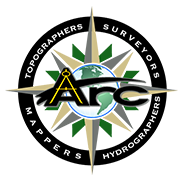
The purpose of the survey was to support a Site Inspection (SI) at Area UXO 16 at the Atlantic Fleet Weapons Training Facility (AFWTF), Former Vieques Naval Training Range (VNTR) and Former Naval Ammunition Supply Detachment (NASD).
This area of assessment included: ship anchoring points where munitions may have been transferred, areas where munitions may have been inadvertently fired into the water from NGF or ATG bombing, and areas where the explosive safety arc from open burning/ open detonation activities may have extended into the water.
The survey areas included numerous reefs, shoals and shore lines that interrupted the pre-plotted survey lines.
The expertise and caution of the captain and crew resulted in zero instances of grounding of the equipment and/or vessel.
Similarly there were zero instances of catching fish traps.
Features with relief of 1 meter or more were mapped for reference in future DGM operations. Several known shipwrecks and sunken boats were observed and were also mapped. Most 1 meter or greater relief areas occurred along shore lines, islands, reefs and shoals primarily in shallow water.