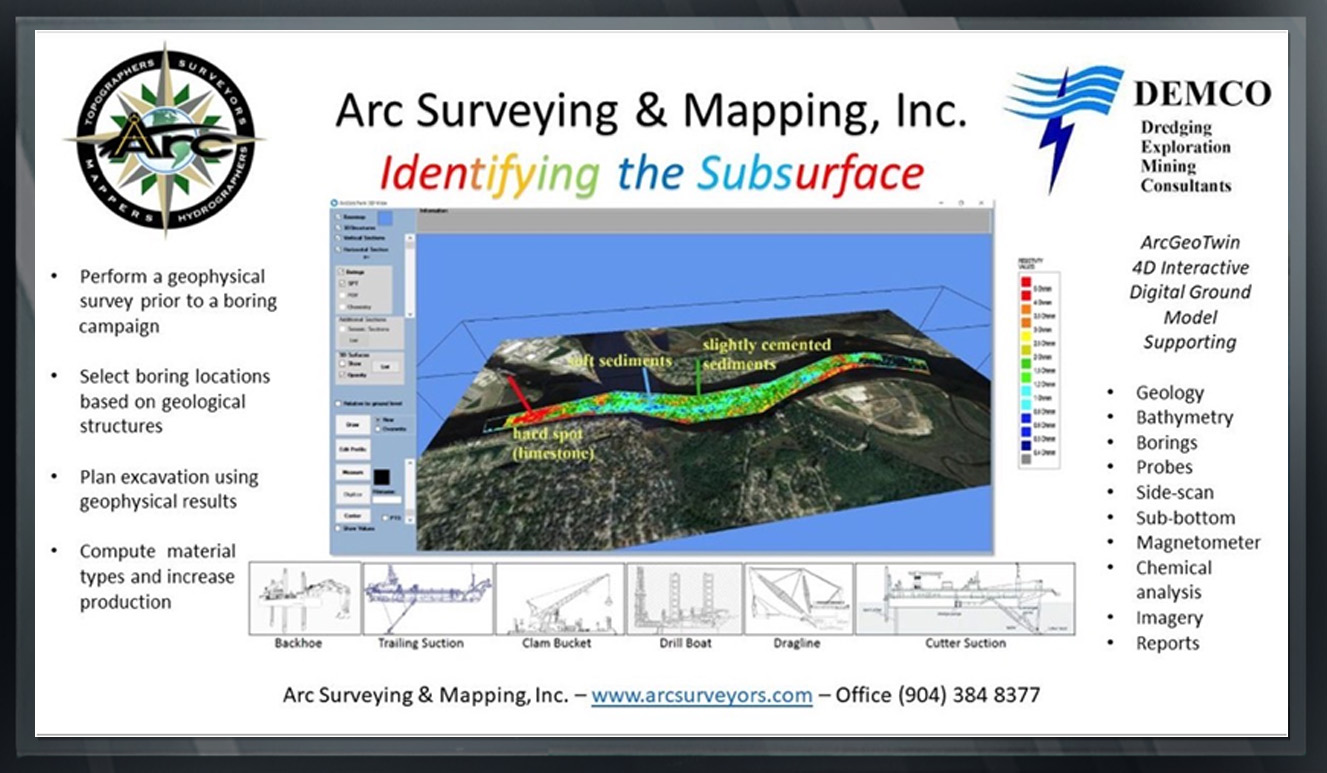
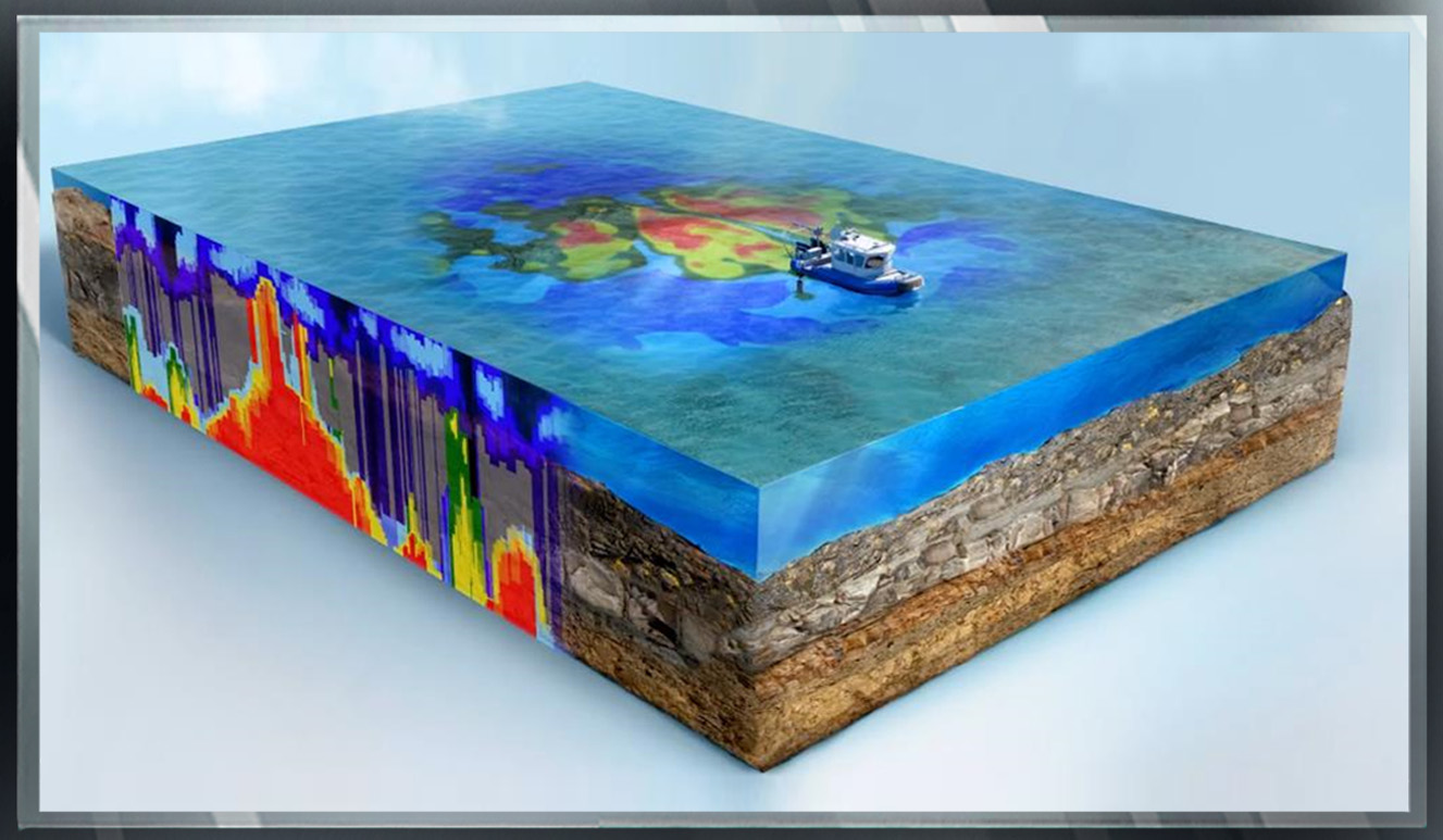
ADVANCED GEOPHYSICS

...

HARBOR DEEPENING, JACKSONVILLE, FL

  • JAXPORT currently supports more then 138,000 jobs throughout the region and creates $31 billion in economic impact every year.
  • JAXPORT has grown Asian container volumes nearly 100 percent since 2012.
  • Local jobs associated with JAXPORT’s Asian business grew more then 57 percent in a five-year period.
  • These jobs and this business depend on harbor deepening to accomodate more cargo aboard today’s bigger ships.
  • More then 15,000 jobs are created or protected by this project.
  • JAXPORT’s leadership worked diligently to keep this project on time, reducing the scope and ensuring that the returns far outweight the cost.
  • The best environmental modeling in the world, plus peer review by scores of independent scientists, advocates for the environmental safety of the full project design.

More infromation about the Harbor Deepening project is available on the USACE website.


The deepening project included construction of a new turning basin adjacent to the Blount Island Marine Terminal that allows larger vessels to turn at Blount Island berths. The turning basin is slightly larger then the turning basin at the port’s Dames Point Marine Terinal, which routinely turns vessels of 1,100 feet (335.3 meters) in length.

The Jacksonville deepening project is the first project of its kind in the United States to include funding from a private business. Funding sources include federal government, the State of Florida, the City of Jacksonville, JAXPORT, and private partner SSA Atlantic.


CORE BORINGS VERSUS ARC/AQUARES GEOPHYSICS


ACOE BORING EXPLORATIONS

Fifty-four (54) years
Exploratory boring campaigns
74 core borings provided in dredging
contract documents.


ADVANCED GEOPHYSICAL SOLUTIONS

A single (1) week survey
Aquares geophysical campaign
3 core borings can describe the subsurface
utilizing an Aquares Geophysical Survey.


Although the geology changes rapidly and is a mixture of rock, cemented and soft sediments, each geophysical structure, including layering can be identified and quantified in the ArcGeoTwin 4D Interactive Digital Ground Model.


PLANNING THROUGH UNDERSTANDING THE SUBSURFACE


Select proper equipment based on material descriptions and resistivity values


ARCGEOTWIN INTERACTIVE DIGITAL GROUND MODEL


THE ARCGEOTWIN 4D INTEGRATED DIGITAL GROUND MODEL PROVIDES:

  • x,y,z and resistivity values of the entire subsurface to a depth of 40 ft. below the existing bottom
  • Models referenced to local horizontal & vertical datum
  • Geology, color coded by resistivity values
  • Import project design
  • Import bathymetric surveys both historical and current
  • Import side-scan sonar imagery & sub-bottom survey profiles
  • Import core borings (digital and original PDF)
  • Compare core boring geotechnical data to Aquares geophysical data
  • Import chemical analysis
  • Import probes and bottom surface ponar grab samples
  • Import jobsite photos & videos
  • Compute material type quantity calculations
  • View and export data in horizontal and vertical sections
  • Choose excavating equipment types based on subsurface resistance values and material types
  • Choose boring locations scientifically using geological structures
  • Compare contract plan data to jobsite conditions

BENEFITS OF AN AQUARES GEOPHYSICAL SURVEY
PRIOR TO CORE BORING CAMPAIGN


  • Core borings identify subsurface material structures only at the boring hole location. Arc/Aquares surveys describe the entire subsurface permitting accurate quantity calculations.

  • GCore borings do not identify the extent of high horizontal and vertical geological variability. Arc/Aquares surveys define the location, position and layering of each subsurface structure.

  • Core borings are expensive and require time consuming multiple site investigations – numerous borings are required to describe the subsurface. Arc/Aquares 4D models describe the entire subsurface reducing the number of borings necessary. An Arc/Aquares geophysical survey is economical, often costing less that the mobilization of a core boring drill barge.

  • GCoring boring acquisition is costly and time consuming. Most Arc/Aquares surveys require one (1) week of data collection. Survey results are provide within two (2) weeks. Data are provided in 4D models on Arc’s Jacksonville Florida server 24/7.

  • Hydrographic surveys are performed under the direct supervision of a professionally registered hydrographer and PLS.

  • Geophysical surveys are provided under the direct supervision of a professional geophysicist